
How AI Road Intelligence works

Our AI Road Intelligence platform transforms ordinary refuse collection vehicles into mobile infrastructure inspection units. Every collection route becomes an opportunity to continuously monitor the condition of roads and roadside assets without deploying dedicated survey vehicles.

The system combines high-resolution cameras, GPS positioning, artificial intelligence, cloud processing, and an intuitive management dashboard to create a continuously updated digital view of the entire road network.

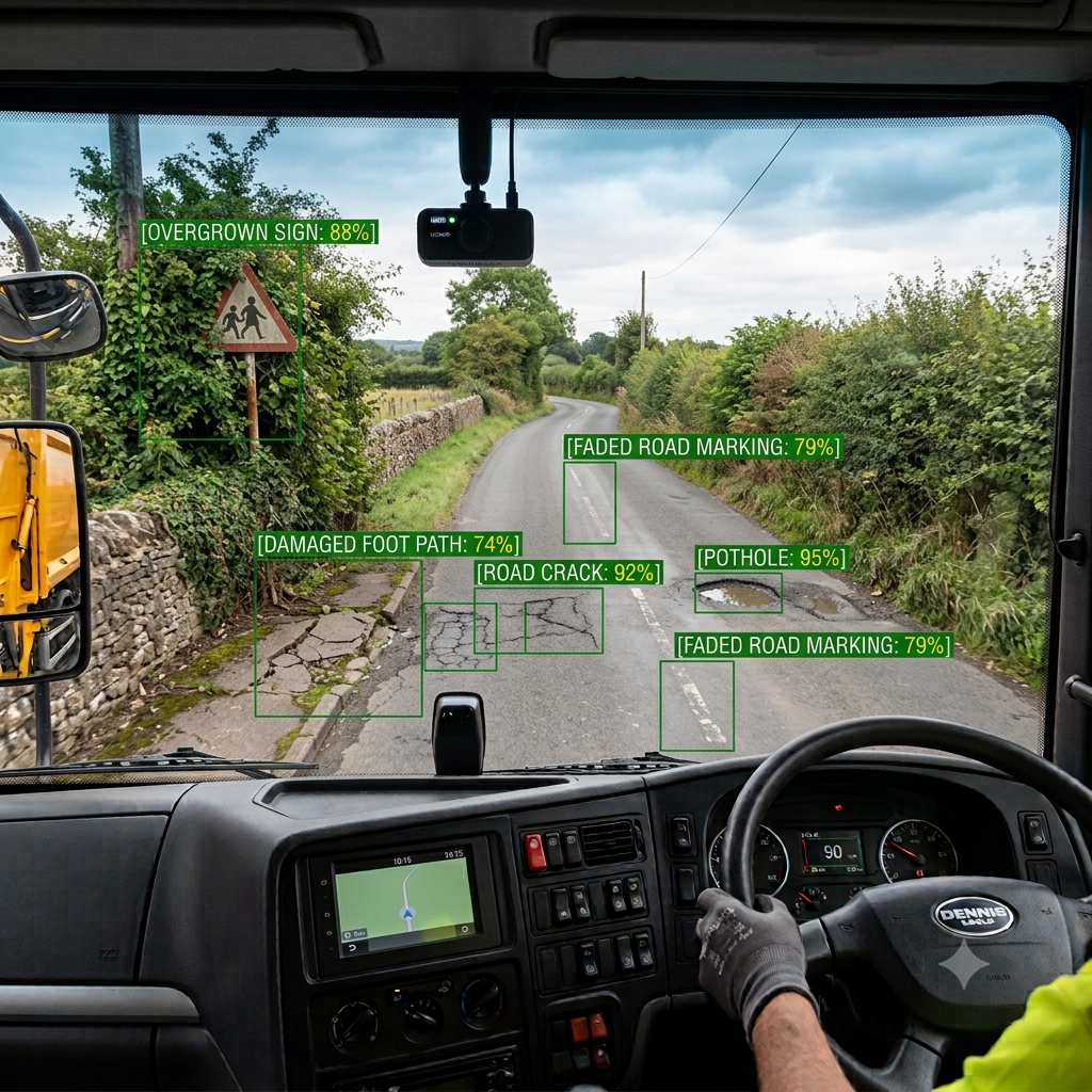
Cab-view camera feed with RoadIntel AI detecting potholes, cracks, faded road markings and overgrown signs in real time
Step 1

Continuous data collection

High-definition cameras are installed on refuse collection vehicles. As vehicles complete their normal collection routes, they capture video imagery of every road they travel.

Each image is automatically tagged with:

  • GPS location
  • Date and time
  • Vehicle direction
  • Speed
  • Road segment

Because refuse vehicles repeatedly travel residential streets throughout the year, the platform provides regular updates on infrastructure conditions without requiring additional inspections.

Step 2

Secure cloud upload

Captured footage is securely uploaded to the cloud either in real time using mobile data or automatically when vehicles return to the depot via Wi-Fi.

The system organises every image according to its precise location, allowing inspections to be compared over days, weeks, months, and years.

Step 3

AI image processing

Once uploaded, advanced computer vision models analyse every frame. The AI has been trained to recognise hundreds of different infrastructure features and defects, including:

Road defects

  • Potholes
  • Defective road marking
  • Pavement defects
  • Road debris
  • Damaged signs

Road assets

  • Traffic control assets
  • Safety infrastructure
  • Lighting & electrical
  • Urban & road infrastructure
  • Smart infrastructure
  • Line and surface markings
  • Street furniture and drainage
  • Special objects

Every object is detected, classified and accurately located on a digital map.

Step 4

AI quality assurance

Each detection is assigned a confidence score. The platform automatically removes duplicate detections from multiple vehicle passes and compares historical observations to identify whether an issue is:

  • New
  • Deteriorating
  • Unchanged
  • Already repaired

This provides a living history of every defect and asset across the network.

Step 5

Digital road network

The processed data creates a continuously updated digital representation of the road network. Instead of isolated inspection reports, engineers receive an always-current view showing:

  • Road condition
  • Asset inventory
  • Defect locations
  • Maintenance history
  • Inspection frequency
  • Infrastructure trends

Every inspection builds a richer picture of network health.

Step 6

Dashboard & decision support

Authorised users access a web-based dashboard that presents all findings in an interactive GIS environment. Users can:

  • Search any street or location.
  • View detected defects on an interactive map.
  • Filter by defect type or severity.
  • Review historical imagery.
  • Compare inspections over time.
  • Monitor asset condition.
  • Export reports.
  • Create and assign maintenance tasks.

This enables engineering teams to prioritise maintenance using objective evidence rather than reactive reporting.

Step 7

Predictive intelligence

As more inspections are collected, AI identifies trends across the network. The platform can highlight roads showing accelerating deterioration, identify recurring defects, monitor repair performance, and predict where maintenance will soon be required.

Rather than reacting to complaints or emergency repairs, authorities can plan preventative maintenance using real-world data gathered every day.

A smarter way to inspect roads

Traditional road inspections rely on dedicated survey vehicles, manual inspections, or public reports—all of which provide only occasional snapshots of infrastructure condition.

Our AI Road Intelligence platform changes this model by using municipal refuse collection fleets that already travel almost every street on a regular basis.

The result is continuous, cost-effective monitoring that provides councils with up-to-date, actionable intelligence, enabling faster decisions, more efficient maintenance planning, and better management of public infrastructure.